News & Press Release
Weathernews Develops a New Global Weather and Wave Forecasting System with World-Class Accuracy
23% Improvement in Forecast Accuracy, with a Marine Weather Dataset Now Available via an API Geared for the Maritime Transport Market
Achieving Data-Driven Operations Management and Advanced Performance Analysis to Drive Digital Transformation in Maritime Transport
Offshore & Neer Sea > Offshore Energy > Shipping >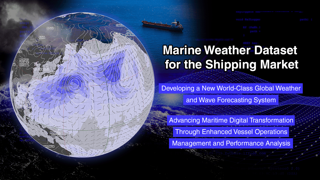
Weathernews Inc. has developed a new Global Weather and Wave Forecasting System with world-class accuracy and has also commenced sales of a marine weather dataset tailored to the maritime transport market. Highly accurate weather, marine, and navigation data from SeaNavigator, Weathernews' marine weather service, will be provided via an API.
With recent surges in fuel prices and stricter environmental regulations compounded by unforeseen route changes caused by geopolitical risks significantly impacting costs and environmental footprints, demand has risen for precise data that can be used to objectively assess and analyze voyage safety and economic efficiency, as well as to build more sophisticated operations management systems. Weathernews developed the proprietary Global Weather and Wave Forecasting System to provide data with even greater precision and has found it to be 23% more accurate in forecasting wave height than its predecessor. The system provides high-accuracy, high-resolution forecasts of such maritime conditions such as wind direction, wind speed, and waves on a 0.125-degree (approximately 10+ km) grid.
This dataset packages a vast amount of weather and oceanographic data, including forecasts and historical data on waves and wind generated using the Global Weather and Wave Forecasting System, as well as data on typhoon tracks and sea ice for oceans worldwide and approximately 2,300 major ports, along with “navigation data” provided by SeaNavigator, such as route simulations, fuel consumption, and vessel speed. Weathernews aims to support voyage safety, economic efficiency, and environmental performance through data, helping captains and operations managers around the world make informed decisions.
Inquiries about this service | See here for Weathernews’ data lineup |
Driving DX in Maritime Transport Through High-Accuracy Marine Weather Data
In recent years, dramatic improvements in maritime communications infrastructure have accelerated digital transformation (DX) in maritime transport, with companies pursuing system integration, AI utilization, and the development of autonomous navigation technology. With rising fuel costs and unforeseen route changes caused by geopolitical risks, demand has also grown for real-time forecast data that can help make timely navigational decisions, such as quickly redesigning optimal routes that balance safety and economic efficiency.
Moreover, amid increasingly stringent environmental regulations worldwide, CO2 emissions are now positioned as a direct cost that affects corporate profits, with historical data growing in importance for regulatory compliance and vessel performance analysis. It is against this backdrop that Weathernews has begun offering the Marine Weather Dataset, a package featuring weather, marine, and navigation data.
New Global Weather and Wave Forecasting System Increases Wave Forecast Accuracy by 23%
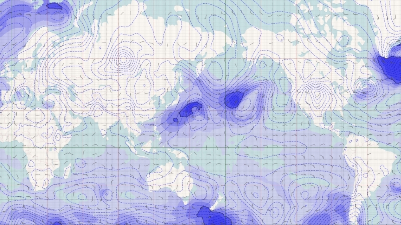
Weathernews has developed a new Global Weather and Wave Forecasting System with world-class accuracy and high resolution to capture rapid weather changes at the earliest stage possible. The system uses an approach that combines over 80 forecast scenarios generated from ensemble forecasts operated by the world's leading meteorological agencies, along with meteorological satellites and the vast volume of vessel observation data possessed by Weathernews. Rather than relying on a single forecast model, it extracts the most statistically probable data from a large number of forecast scenarios, and then corrects this data to achieve high-accuracy forecasts of waves and maritime winds.
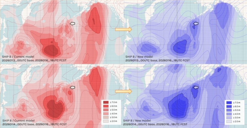
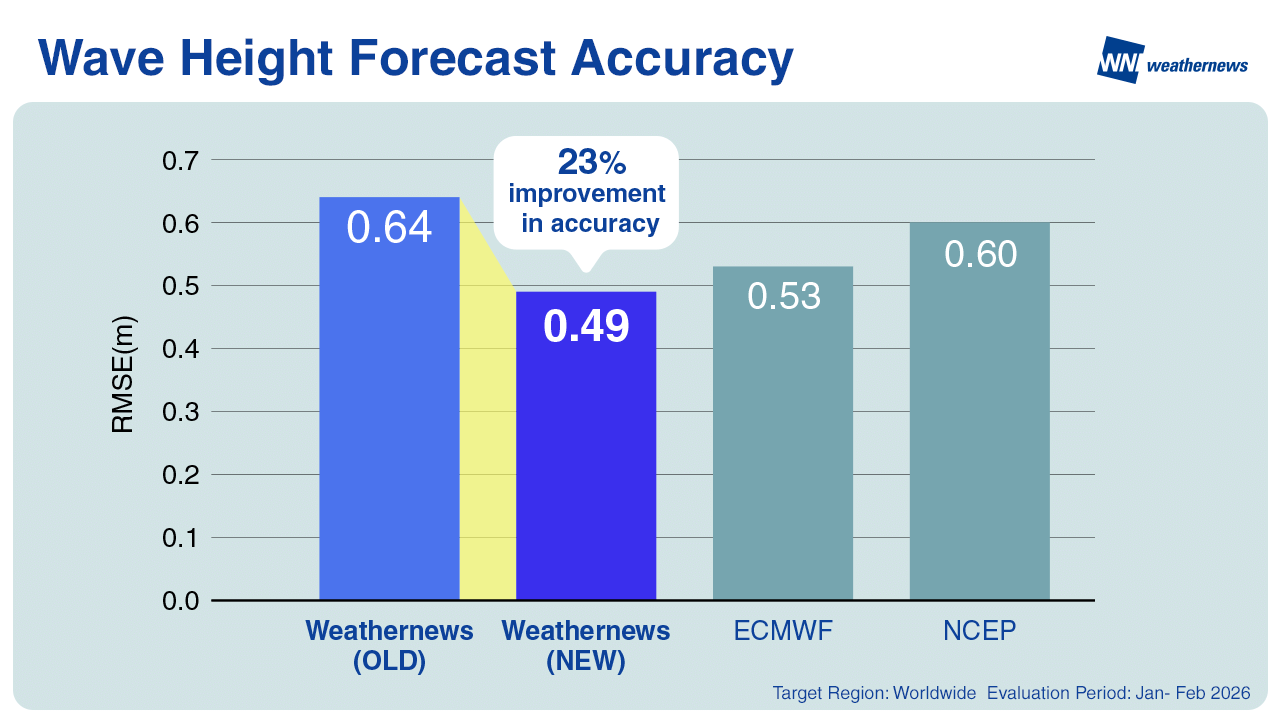
This system has successfully reduced significant wave height forecast errors by approximately 23% compared to the previous system (comparing the root mean square error (RMSE) of wave height forecasts up to 7 days ahead across all ocean areas from January to February 2026). Weathernews has also verified that its wave height forecasts are more accurate than those of the European Centre for Medium-Range Weather Forecasts (ECMWF) and the National Centers for Environmental Prediction (NCEP). This makes it possible to more accurately capture rising wave heights caused by rapidly developing low-pressure systems.
Wave, wind direction, and wind speed forecast data from this system will be provided through the Marine Weather Dataset for the maritime shipping industry.
Provision of a Marine Weather Dataset for the Maritime Transport Market Begins
This dataset packages two types of data: weather and marine data and navigation data. Data can be retrieved via API through the cloud, making integration with existing corporate systems easy. Users can specify latitude and longitude to retrieve relevant data easily.
The weather and marine data includes a comprehensive range of data, such as wave height, wind direction, wind speed, and temperature, for approximately 2,300 major ports and shipping routes worldwide, along with forecast trackers for tropical cyclones (typhoons, hurricanes, and cyclones) worldwide and composite data on tidal currents and ocean currents. The dataset also includes the high-accuracy, high-resolution wave and wind forecasts from the newly developed Global Weather and Wave Forecasting System.
While the navigation data is available only when using the weather routing service on Weathernews’ SeaNavigator, it can provide data on voyage records, reports, and performance analysis, such as vessel tracks, voyage plans, fuel consumption, and noon reports from vessels.
Service Specifications
Data Type | Marine Weather Dataset for the Maritime Transport Market |
Spatial Resolution | 0.125-degree grid (1.0-degree grid for some data) |
Update Frequency | Every 6 hours or once daily |
Forecast Interval | 1 hour, 3 hours, 6 hours, or 1 day (depending on the data type) |
Forecast Period | Up to 15 days ahead |
Delivery Method | API (GRIB/BINARY/JSON/XML format, with some data available in KML format) |
Details on Data Lineup
Data with underlined names use forecast values from the Global Weather and Wave Forecasting System.
Category | Name | Main Content & Data Collected |
Weather and Marine Data | Weather Data
| Forecasts and historical data for sea level pressure, wind direction and speed, temperature, humidity, precipitation, and visibility |
Marine Weather Data
| Forecasts and historical data for waves (significant wave height and mean wave period; primary wave, secondary wave, swell, and wind wave height, direction, and period), ocean currents, and sea surface temperature | |
Front Data
| Front types (warm front, cold front, occluded front, and stationary front), position coordinates, and central pressure forecasts | |
Global Storm Data | Total number of tropical cyclones (tropical depressions, tropical storms, typhoons, hurricanes, and cyclones), along with basic information, track forecasts, real-time analysis, and historical tracks (name, type, current position, central pressure, maximum sustained wind speed, maximum gust speed, radius of storm and gale force winds, and direction of movement) | |
Iceberg Data | Iceberg forecasts and historical data (number of icebergs, latitude and longitude) | |
Ice pack Data | Ice pack forecasts and historical data (number of ice packs, latitude and longitude) | |
High Resolution Weather Data | High-resolution weather forecasts (0.125-degree grid) for specific sea areas in the North Pacific, North Atlantic, and Southeast Asia | |
High-resolution Marine Weather Data | High-resolution wave forecasts (0.125-degree grid) for specific sea areas such as the North Pacific, North Atlantic, and Southeast Asia | |
Global High-resolution Weather & Marine Weather Data | High-resolution weather and marine data worldwide (0.125-degree grid) | |
Tidal Composite Current Data
| High-accuracy composite tidal current forecasts and historical data combining tidal current and ocean current forecasts for 20 major sea areas worldwide (waters around Japan, the Strait of Malacca, the east coast of North America, and others) | |
Weather and Marine Data Along Tracks | Weather & Marine Weather on Tracks
| Weather and marine forecasts and historical data for specified points (latitude and longitude) and times along tracks |
High Resolution Weather & Marine Weather on Tracks
| High-resolution wind, wave, and ocean current forecasts and historical data (0.125-degree grid) for specified points (latitude and longitude) and times along tracks | |
Port Weather and Marine Data | Global Port Forecast (Port weather and marine forecasts)
| Weather and marine forecasts for major ports worldwide |
Global Coastal Port Forecast (Weather and marine forecasts for specific locations other than ports) | Weather and marine forecasts for specific locations other than ports (coastal facilities, etc.) | |
Navigation Data (*1) | Voyage Track
| Voyage data, route records, and voyage plans for vessels using the Weathernews weather routing service |
Vessel Report (QRT)
| Report data submitted by vessels to Weathernews | |
Logbook+ Data | Data provided through SeaNavigator's Logbook+ | |
Sea Margin (Delay rate) | Simulation data showing how much additional time or fuel is required compared to calm sea conditions | |
Post-Voyage CP Warranty
| Finalized (post-voyage) performance evaluation data on whether the vessel met the performance guaranteed under the charter party (CP) after the voyage is complete | |
En Route CP Warranty (In-voyage charter party evaluation) | Preliminary (enroute) performance evaluation data on whether the vessel is meeting the performance guaranteed under the charter party (CP) during the voyage | |
Tonnage Allocation Planner Voyage simulation | Simulation results for the shortest route and the route recommended by Weathernews | |
Hire Bunker Cost Report (Fuel cost forecast) | Calculates fuel costs based on estimated fuel consumption | |
Cost Sheet (Voyage cost forecast) | Forecasts total voyage costs to help in selecting and evaluating the lowest-cost route | |
Damage Risk
| Risk of damage to the hull and cargo from encountering inclement weather | |
Emission Dashboard (CO2 emissions) | Visualizes CO2 emissions on in-house systems for compliance with environmental regulations (CII/EEXI/EU-ETS) |
*1: Navigation Data is available only to companies using the Weathernews weather routing service.
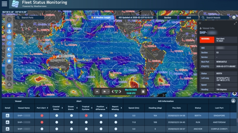
SeaNavigator: A Single Marine Weather Service That Integrates All Navigation and Weather Data
Since October 2024, Weathernews has offered SeaNavigator, an integrated marine weather service that aids in environmentally sound, safe, and economically efficient operations for all types of vessels.
The service provides all the navigation and weather data needed for maritime operations on a single platform: from the latest high-resolution wave and wind forecasts to optimal route selection, calculation of arrival times and fuel consumption, and analysis of vessel performance and CO2 emissions.
AI accesses vast weather, marine, and navigation data to detect inclement weather risks for vessels in real time, automatically generate weather and marine condition reports, and perform in-depth analysis that would be time-consuming to perform manually.
integrated marine weather service
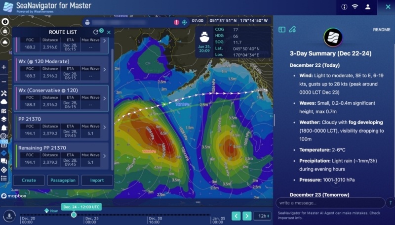
In December 2025, Weathernews also launched SeaNavigator for Master, a next-generation operations support platform in which AI assists captains with operational decisions in an interactive format.
Weathernews has put into practical use the world's first AI service designed to help captains make operational decisions on board by enabling them to ask the AI about weather risks along routes and at ports, fuel efficiency and speed forecasts, and other data directly tied to voyage planning. Users can also check the latest high-resolution wave and wind forecasts and update voyage plans with optimal route simulations.
Weathernews provides solutions optimized for individual maritime transport operator workflows, from navigation-focused data via API to content that can be operated on the SeaNavigator screen. Weathernews aims to continue leveraging the navigation support expertise and vast weather and marine data it has built over more than 40 years to help vessels around the world achieve safe and efficient voyages.